


The Ohio River is one of the most picturesque and fascinating waterways in the United States. The river’s scenic beauty, combined with the numerous wilderness islands and wildlife in the upper Ohio Valley, make it a perfect destination for boating and recreation. From kayaking and canoeing to pleasure craft, the waterway allows river-goers the chance to explore its many channels and coves or simply enjoy the scenery from the water. With warm weather here to stay, one need not look any further than the Ohio River for a chance to enjoy the great outdoors along this wonderful waterway.
One of the most striking features of the upper Ohio River is the numerous islands that dot its waters. These islands are perfect for exploring, fishing, camping, and picnicking. Because of their silty and relatively shallow shores, boaters can easily beach their boats or tie off on the islands allowing them to enjoy their natural serenity.
In addition, the upper Ohio River and islands are also home to a wide variety of wildlife. The river provides a habitat for a variety of birds and mammals, including bald eagles, blue herons, deer, beaver, river otters and minks. Additionally, it is also home to a variety of fish species, including bass, catfish, gar, and musky. According to the U.S. Fish and Wildlife Service, “The Ohio River Islands National Wildlife Refuge was established in 1990 to protect, conserve, and restore habitat for wildlife native to the river and its floodplain. Refuge islands are gradually returning to forested conditions after years of farming, oil and gas extraction, and other activities. Migratory birds and endangered freshwater mussels are among the important wildlife emphasized for protection on the refuge…”
If their importance wasn’t made clear enough, the Ohio River Islands National Wildlife Refuge is counted among more than 560 refuges in the National Wildlife Refuge System, making it by far the world’s largest and most diverse network of lands and waters devoted specifically to wildlife and conservation.
Let’s take a look at some of the accessible islands within an hour’s drive of Wheeling.
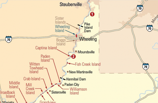
Sisters Islands (Formerly Coney Island)
Sister Islands (located about 4 miles north or “upriver” from Wheeling) was once known simply as “Coney Island”, which was in reference to the largest of the three islands. Prior to 1905, the island was home to a small café and an outdoor pavilion used for dances and events. In June 1905, an amusement park constructed by the Wheeling Amusement Company opened with more than 6,000 guests attending, accessing the island via excursion steamboats and pleasure craft. The Amusement park boasted a number of attractions, including a stadium with a capacity of 2,500, a roller coaster, Ferris wheel, a German beer garden bar, numerous shows, and much more.
However, the planners did not think their investment through. Within two years, floods had wreaked havoc on the island and its sisters multiple times. All was abandoned once and for all in 1913, thus ending what was once a thrilling tourist destination on the Ohio River. Continued erosion from multiple floods over the past century, in addition to the construction of dams, has not only drastically reduced the size of the islands but all but erased the history that once graced the natural wonder.
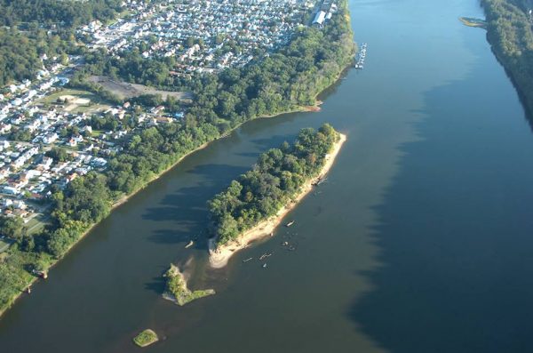
Captina Island
Captina Island is located about 20 miles south of Wheeling and directly across from the northern end of Powhatan Point, Ohio. Accessing the island is easily done from the Powhatan’s marina where a boat launch and docks are available.
The wilderness island has long been associated with Native Americans, including the Mingo Tribe, and settler activity due to its proximity to Captina Creek. Both island and creek of the same name are written about in Allen Eckert’s captivating book, “That Dark and Bloody River” for those history buffs. One account describes the death of George Wetzel in 1782, older brother of notorious Indian killer Lewis Wetzel. While passing the island, he succumbed to bullet wounds sustained from an Indian ambush somewhere downriver. There at the head (upper end) of the island, he was buried by his brothers Martin and Lewis and their father John, Sr. Days later, the men and several others returned to the island and disinterred George’s body and reinterred him in the family’s cemetery at the Wetzel farm along Wheeling Creek.
In later years, the island was farmed, the evidence of which is further shown in the number of old house foundations that remain. However, it’s because of that very reason that much of the island is dangerous for exploring due to the existence of cisterns, wells and unstable foundations hidden beneath years of silt and undergrowth. One misstep and your afternoon adventure may turn into an Indiana Jones-style deathtrap.
For those interested in a more leisurely bask in the sun or swim in more shallow waters, the island’s backchannel provides an ideal site. But word to the wise – the channel is extremely shallow these days allowing only the smallest of craft (canoes and kayaks primarily) to enter its waters. Those indulging in the blissful spot, however, won’t be the first to do so. Children found the site to be ideal not only for swimming but a natural playground where they could swing off vines and ropes into the deeper swimming holes of the channel.
Fish Creek Island
Just a few miles downriver from Captina Island rests Fish Creek Island between Powhatan Point and Clarington, Ohio. The massive island, named after the creek that empties into the Ohio from the West Virginia shore near it, sits almost perfectly in the middle of the Ohio River and is approximately half-a-mile in length. While boasting a less prominent but nonetheless important history, the island was almost single-handedly the reason for the creation of the National Wildlife Refuge.
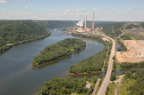
Taking your first steps into the dense foliage, a high pitch screech through the trees causes the hair on your neck to stand up and your heart to skip a beat. Fear and excitement grip you as the rustling grows louder overhead as the screeching intensifies. Could it be that there are dinosaurs roaming free on this island? Of course not! You’re not on John Hammond’s tropical Jurassic Park island and those are not pterodactyls flying above. You just happened to set foot on West Virginia’s largest rookery of Blue Heron nests and they’re letting you know it.
Thanks to the implementation of the Clean Water Act, profound improvements to the quality of water and habitats along the Ohio resulted in a resurgence of native wildlife that had otherwise vanished, including Blue Heron, where hundreds of nests were discovered on the island in 1989.
Prior to the Clean Water Act and National Wildlife Refuge designation, the island was explored for oil and gas. By the mid-1950s, Consol Energy had purchased the island to mine for coal but those plans never materialized. Eventually, the company donated the riparian reserve leading to its eventual designation and recognition as a refuge.
The “Long Reach”: Paden Island, Williamson Island, Witten Towhead and the Sistersville Ferry
Situated about 45 mins south of Wheeling along the Monroe County, Ohio and Wetzel County, WV shorelines begins a 17-mile stretch of the Ohio known as the “Long Reach.” The history and scenic beauty of the Long Reach is made even more so by three islands that are close in proximity but varying in size.
For an even more unique experience and just few dollars, take the short jaunt down Route 2 to Sistersville, WV and hop on the Sistersville Ferry, the only operating ferry left on the Upper Ohio River. For over 200 years, a ferry has continuously operated on the site offering riders a short trip across the river to Ohio’s Route 7 while providing unparalleled views of the Long Reach.
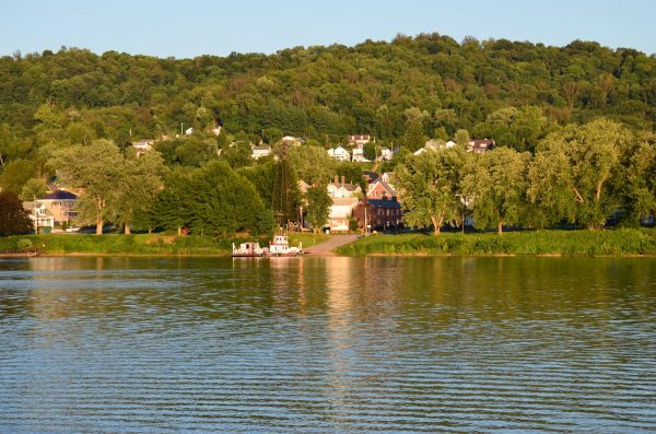
Prior to becoming president of the United States, a young George Washington made an extensive trip down the Ohio in 1770 and camped at sites along the stretch of the river, referring to it in his diaries as the “Long Reach.” Numerous other events relating to settlers and Native Americans occurred there as well. Next to the ferry landing on the Ohio side in Fly, Jackson Township, is a marker memorializing Washington’s encampment there.
Access to this part of the river is easily achievable through a number of public sites, including the Monroe County Park District’s boat launch at Old Lock and Dam 15 in Sardis, Ohio or from New Martinsville or Paden City, WV’s boat launches.
The first and uppermost of these islands is Paden Island. Named after the first settler in the area (and allegedly the first along the Ohio River between Wheeling and Marietta) Obadiah Paden who was born in 1752 and moved into the area in the late 1700s. During that period, he acquired large sums of acreage in what was then Virginia along the Ohio River and surrounding hills, including the island which now bears his name.
The WPA Guide to West Virginia published the following story about Paden and his island:
“Paden Island was acquired by Obadiah, according to family tradition, through out-scheming the Indian chief, Munsie, who lived on it. Munsie much admired and coveted a gun and powder horn owned by Paden, and one morning came to tell him how, in a dream, these things had been presented to him by Paden. As Indian custom required that Paden make the dream come true, he did so but was very thoughtful for several days. A week later he told Munsie of a dream that he had had, in which the chief had given him the island. Munsie surrendered the island he loved, but told Paden no more of his dreams…”

Today, Paden Island is off-limits to visitors primarily due to the wildlife and other conservation efforts that are occurring on it. Signs posted along its rip-rap-laden shoreline (to prevent erosion) warn trespassers to stay away. However, the island’s deep water back channel provides a picturesque route perfect for pleasure craft and kayaks alike to peruse bald eagles, red ear slider turtles, and other wildlife.
Williamson Island
Just a short distance downriver from Paden Island is the ever-popular and widely visited Williamson Island. The massive island provides stunning panoramic views of the river for miles while framed by on either side by lush green hills. Its soft and silty shores provide an easy and safe beaching for both small and large boats.
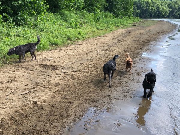
On any given weekend dozens of boats, people, and dogs can be found enjoying the island. Its shallow waters provide the perfect spot for wading, relaxing, and soaking up the sun. The frequent gatherings are affectionately and collectively referred to by attendees as the “redneck yacht club.”
Witten Towhead
Mere yards downriver from Williamson Island sits the small, but mighty Witten’s Towhead – the remnants of what used to be a larger island but now reduced to a small island due to heavy erosion, which is referred to on the river as a bar or “towhead.”
The island derives its name from the historic Witten family whose family farm and descendant still reside opposite it on the Ohio shore. During the oil and gas boom of the late 1800s and early 1900s, it was explored for oil and was dredged for gravel. Today, its primary residents are a large colony of Bank Swallows who nest within its sandy banks.
Along the banks of the Ohio, the Witten Cemetery holds fast to a sign that details much of the rich history of the Witten and Dickerson families:
“Philip Witten was born in Virginia, June 8, 1747, son of Thomas Witten, Sr., and Elizabeth Cecil. He married Ruth Dickerson and lived for a few years seven miles east of Fort Henry, now Wheeling, West Virginia. He was not satisfied here and reasoned that there should be more beautiful and fertile lands farther south on the beautiful river Ohio. In company of his brother-in-law’s Kinsey and Vachel Dickerson, he made a trip down the Ohio in a canoe going as far south as the present city of Louisville, Kentucky, landing and inspecting several sites but finding none that offered the advantages of fertility, beauty, and pleasant location as the site of this farm. Recordings in Marietta Ohio indicate that it was purchased September 1, 1790. The present farm is a portion of the original tract. Since the year 1790, this land has been in the Witten family and farmed by the descendants of the sturdy pioneer who so bravely set up his home on the frontier.”
Natural Paradises Waiting to be Explored
Exploring the Ohio River’s natural islands and their history can be an affordable adventure for those seeking a unique and off-the-beaten-path experience this summer and all within an hour’s drive from Wheeling. If you’re looking for an adventure that is close to home and free, your opportunity awaits. And they don’t just stop here. Twenty-two islands can be found over a 362-mile stretch of the Ohio River between Pittsburgh to Cincinnati and all part of the Ohio River Islands National Wildlife Refuge. These incredible natural habitats can be a budget-friendly way to connect with nature and learn about our region’s rich history.
What are you waiting for? Get out there and explore!
• Taylor Abbott is the treasurer of Monroe County, Ohio, and was born in Wheeling, West Virginia. He is a graduate of Ohio University and is co-founder and president of the Ohio Valley River Museum. He serves on the board directors for the Sons & Daughters of Pioneer Rivermen and is an advisor to the Ohio River Museum in Marietta, Ohio. He enjoys hiking, travel, historic preservation and restoration work. Taylor resides in Clarington, Ohio, with his wife Alexandra in a former church they purchased in 2016 and renovated into their home.