The Life And Death Of ‘Suicide Hill’ Steve Novotney January 27, 2017 30 
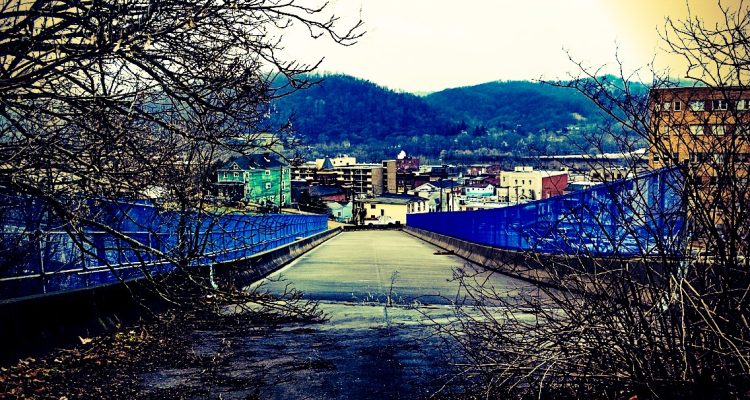
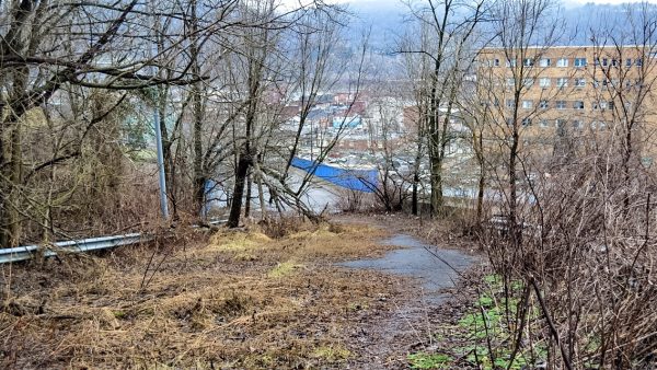
It was cut into the hillside to link the village of Bethlehem to the city of Wheeling and the bridge at the bottom just might be the only span in the state of West Virginia without a pothole in its path. 
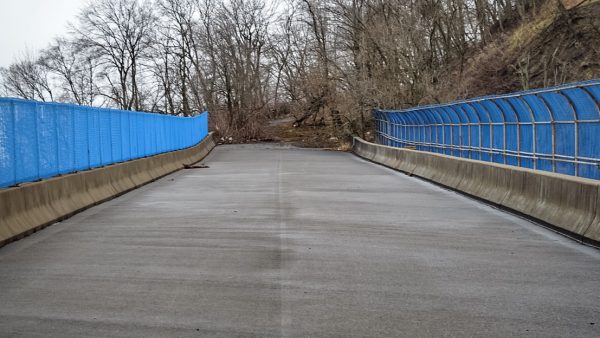
The overpass is Bridge No. 3111, built during the 1980s to span W.Va. Route 2 and connect Chapel Hill Road to 22nd Street that ran adjacent to the Ohio Valley Medical Center in Center Wheeling. The roadway was constructed by the state, current District 6 interim engineer Gus Suwaid said, in the 1950s or 1960s to improve access. The roadway’s technical title is “County Road 6,” but it was known more infamously as “Suicide Hill” because of its swerves and curves and deep drops over the hillside where Big Wheeling Creek flows at the bottom. “But why would anyone refer to the road by that name? I’ve yet to hear a straight answer as far as why it’s been called that,” said Suwaid. “My guess is that the slope of the bridge and the hillside have caused that road to have that nickname. I guess when people drove that steep of a road, they felt as if they were putting their lives in jeopardy. That’s the only reason I can imagine. The top of the roadway in Bethlehem is blocked off by a gate and fencing. “I’m sure it was a roller coaster setting, and it was a very thin roadway, too,” he continued. “But that’s something the people who have lived here for a long time can probably answer better than I can. I’m sure there are people who still live here that used the road at some time.” 
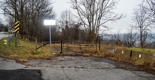
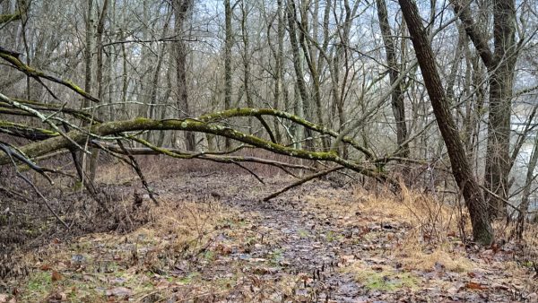
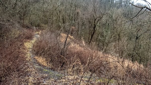
At the top in Bethlehem where the “No Trespassing” sign is posted, the roadway is blocked by fencing that is easily cleared by those wishing to visit this so-called local legend. Such a hiker is quickly met by the impacts nature has provided during the past three-plus decades, and only small patches of asphalt can be discovered during the walk. 
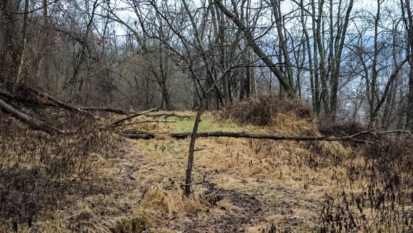
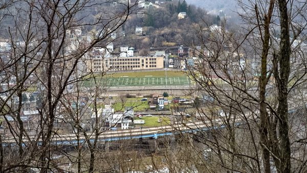
The one-mile road runs along the hillside that overlooks the East Wheeling neighborhood before bending toward OVMC, and there are downed trees blocking the path in a few areas, and four different slip areas must be avoided for safety’s sake. The largest slide, the one that ultimately closed the passage, swept away all but a few feet of the road and gulped the guardrails once in place. The top and the bottom portions of “Suicide Hill” are the steepest areas, but the middle levels out for approximately a half-mile. “A lot of years ago my friends and I would ride down that hill into Wheeling so we could go to McDonald’s and buy their 58-cent cheeseburgers,” recalled Bethlehem Mayor Tim Bishop. “After we got our burgers and ran around town for a while, we would go to my great aunt’s house on Eoff Street for a ride home. During the spring and summer seasons there are portions of the path that are impassable. “We never peddled back up that hill because it was way too steep for us,” he continued. “I really don’t remember any of my friends trying to ride their bikes back up it because we didn’t have these bikes with 24 different gears back then. They had one gear, and it all depended on how fast a kid peddled.” The village’s mayor has not trekked the roadway for many years, but he recalled the massive slips, and he’s been told the tales about why it was known as “Suicide Hill” during his childhood and beyond. “I have heard those stories my entire life, but I’ve not heard a word for a really long time now,” Bishop said. “Today I know all of the those stories I heard when I was a kid were never true, but there were a lot of rumors about it, and we believed them when I was a kid. I think people just told us those to scare us but it never stopped us from riding down into town. “One story I remember is that a school bus full of children wrecked and went over the hillside at some point. The legend was that if we climbed down the hill, we’d still be able to find the school bus,” he explained. “Of course, that was never true, and we never found the school bus, but there were a lot of accidents on it based on what I’ve been told, and I’ve also heard that there were people who went over the edge when it was open.” Downed trees block the path in a few different locations. Bishop also learned those village maintenance workers made efforts to keep the roadway open to motorists. “After I spoke to a couple of people about that road, I found out that the village used to deposit debris in the areas where the roadway had slipped because that was a big problem with that hillside,” Bishop said. “They used to place materials like concrete and things like that when that kind of work was taking place in the village, but I’m told that the practice stopped because it was a losing battle. There were too many slips, and then a really big one took place that ultimately closed the road for good. “It’s been a lot of years since I walked down it, but I can still remember what the big slip looked like. It took out most of the road pretty close to the bottom where the bridge goes over (W.Va. Route 2),” the mayor continued. “I’m pretty sure there’s some people who travel under that bridge now who wonder where the road goes to, and they have no idea the answer is, ‘Nowhere.’” Bridge No. 3111 appears in good condition when traveling below it and walking on its decking although the double yellow line has faded from the effects of weather. Suwaid discovered little factual information on the past project but he did research the reasons why the span was constructed. The former Chapel Hill Road runs along the hillside above the East Wheeling neighborhood. 
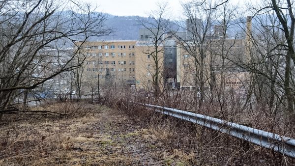
“From what the records indicate the construction of that bridge began in 1981, and from what I can tell from my research, it was built at the same time that the I-470 interchange was constructed nearby,” Suwaid said. “It was a part of the project that included the exit ramp down to 16th Street in downtown Wheeling. Before (W.Va. Route 2) was built, this road continued down the hillside all the way to Chapline Street next to the hospital. “The bridge was built for the access because the new road took away the hillside,” he continued. “From my research I found out that, because of the multiple slips that took place along that road, it was decided not to open that bridge to traffic after it was completed.” Or was it? Suwaid has encountered a few people who have insisted the span briefly welcomed motorists. “I have been told by a few people who believe it was opened for about three months, but then it was closed because of the road up that hill was pretty much slipping away,” Suwaid reported. “But the prevailing story is that it was never opened to traffic, so this is actually something I’ve not been able to verify, but I am sure there are people in this community that know whether it was opened or not. This is the area where a massive slip took place and permanently closed “Suicide Hill.” “Most of the opinions I have collected is that it was never opened,” he said. “The bridge is in great shape, and the decking is in very good condition, but the design of that bridge is not something we would choose today because, over the years, it’s proven to be fracture critical. What that means is the design is not a good one for today’s traffic.” How much did this “Bridge to Nowhere” actually cost West Virginia taxpayers? Suwaid only can offer the price tag such an overpass would possess today. “If a bridge like that was built today it would cost between $3 million and $6 million depending on the foundation work and aspects like that,” the interim district engineer offered. “As far as what it cost back then, I do not have those numbers to offer anything official but inflation rates can be calculated.” According to the Consumer Price Index provided by the federal government, $6 million in today’s economy would have been worth approximately $2.25 million in 1981. Despite the span’s good condition, Suwaid owns no plans to consider renovations to Chapel Hill Road, so the bridge will remain closed for the foreseeable future. This is the only portion of the road where guardrails have remained in place. “I do not see a need to re-address that roadway to increase access because since that road was closed I-470 has been added to that area and that’s how the people now access the areas on that hilltop,” Suwaid said. “Plus, there have never been any businesses or residences along that roadway so that is not part of the equation, too. “That’s why it’s not feasible to put any money into it to re-do it and maintain it,” he continued. “If that changes at some point then we can have that conversation, but with all of the prior slips and the past efforts to prevent those slips, I seriously doubt anyone would want to build another on that hillside because it’s proven to be fairly unstable through the years.” And no, Bridge No. 3111 cannot be removed for use at another location. “I’ve never heard of such a proposal, and I seriously doubt it could be removed from its foundation because it is embedded into the rock of that hillside,” Suwaid explained. “That’s pretty hard to even imagine, and it really seems as an unachievable goal. Most bridges are designed with the specific location in mind because every bridge is different. “Plus, that bridge was constructed at a 12.5-percent grade because of the steepness of that hillside, and I doubt there is another location where a 12.5-percent-grade bridge would make sense,” he continued. “I wish it were possible, but it’s not.” Only the top of the road and the bottom have retained significant amounts of pavement. As far as Bishop is concerned, “Suicide Hill” has been forgotten by area residents because of the amount of time that’s passed since its closure. After viewing photographs of the passage’s current condition, Bethlehem’s mayor doubts a child could navigate a mountain bike from top to bottom today. “Since I was elected as mayor not a single resident of Bethlehem has come to me about that road,” Bishop said. “No one has ever proposed an idea about what to do with it. I think it’s been closed for so long now that most of the people who live here now have forgotten it even exists. Today there’s an entire generation that’s driving now, and that road has never been an option for them. “I know when I drive out Chapel Hill and Hubbard Lane, I don’t even look at the gate that blocks it from traffic. It’s just there,” he continued. “I’m sure some people go down there with their dogs or to try to take photos of Wheeling because the views are great when the trees aren’t full of leaves in the spring and summer.” However, if residents expressed interest or if an organization proposed a future-use idea, Bishop admitted he would be intrigued by such a conversation. “I’d be willing to listen to any and all ideas for using the path for something again, but I seriously doubt it will ever be a roadway again because of the slips,” he said. “But if someone wants to talk about making it a hiking trail or a bike route or something like that, I’d be open to discuss it and to see what our residents think about the idea. Construction of the bridge began in 1981 so motorists would maintain access to Bethlehem via Chapel Hill Road. “Since it is pretty steep whether you’re going up it or down it, there could be a need for a rest shelter and water along the route, and those are ideas that we can talk about,” Bishop continued. “I’d be very curious to see if people would be interested and if they would make it part of what they do for physical fitness.” Suwaid, too, would listen, and that is because similar projects have been proposed and accomplished in several areas of the Mountain State. State funds, though, would not be made available for any portion of such a project. “Re-purposing old roadways for other uses is something that we have done throughout the state of West Virginia, so it’s not impossible. If that’s a conversation concerning this roadway then we would have to take a hard look at it because of the history with slips and slides,” Suwaid said. “But if a group comes in and they are willing to do the work that is necessary to ensure safety, I’m sure it’s something we would consider. “Such a group would work with our Planning Division so an assessment could be conducted so we can see what’s really possible,” he said. “If everyone is satisfied from the engineering standpoint and such a group would be willing to take ownership of such a trail as far as upgrades and maintenance are concerned, it is something that could provoke a lot of interest in the future. Maybe if something like that happens people will then call it something different than ‘Suicide Hill.’” (Photos by Steve Novotney) Share this:Click to share on Facebook (Opens in new window)Click to share on Twitter (Opens in new window)Click to share on Reddit (Opens in new window)Click to share on Pinterest (Opens in new window)Click to share on LinkedIn (Opens in new window)Click to share on Pocket (Opens in new window) 30 Responses Bruce Kibby July 21, 2017 I also heard the the road was the brainchild of a Wheeling mayor with the last name of “Bachman.” The story was that he, or maybe some of his relatives and close friends, lived in Bethlehem and wanted a shorter route to Wheeling and the OVGH/Center Market area. Despite much town council opposition, he was able toramrod the project through and the resulting dangerous and ill-planned road was not only know as “Suicide HIll”, but also referred to by many as “Bachman’s Folly.” Log in to Reply Bruce Kibby July 21, 2017 I live in the eastern panhandle now, but when I lived in my birthplace of Wheeling I drove “Suicide HIll” almost every weekday during the summer of 1971 to get from my home in Elm Grove to my summer job at Companion Products Co which was located below the Center Market. Just found it a more “fun” ride than going via 29th St. It was also a great motorcycle road to drive up with all it twists and turns. My favorite memory of that hill, however, comes from my grandmother, Thryza Leithe. She lived on 18th St. in Wheeling and Suicide Hill was part of the view you’d see from her front porch. She was a great “story-teller” and when I was around 4 years old, she told me about the road and said that many of the cars that went down that road ended up wrecking and killing all occupants. Since I had no doubt that anything my “nana” told me just had to be true, I believed the story wholeheartedly. Whenever I visited her, I spent many hours out on that porch watching cars go down the hill (it was especially easy to see them in the fall and winter, or during night when their headlights made them stand out) and just waiting to see one of them take a fast and fatal plunge. If I became weary of watching the hill and not seeing any wreck, Nana Thurs would sometimes say, “You should have visited me yesterday, I saw three go over!” That put me right back in the mood to do more hill-watching from her porch. Another funny memory I have is about the sign the village of Bethlehem put up when they closed the road (late 70’s?) . It was a large white sign with bold black letters ominously proclaiming “SUICIDE ROAD CLOSED.” If you weren’t a local and saw that sign, it would certainly give you pause to ponder its meaning. Wish I’d have taken a picture!! Log in to Reply Barb July 17, 2017 No school bus every went over the hill. And as far as I remember , no cars. I went down once, was so scared, never did again. Log in to Reply Margaret Stenger July 16, 2017 Where is the Redmen Cemetery in conjunction with Suicide Hill? And how can you get to it? Log in to Reply Jeremy stillwell March 29, 2018 Its really far off through the woods it’s easier to get to off Bowman’s edition Log in to Reply Rich Beaver February 24, 2017 IAs I recall a bar called Hi- UP was on the top of hill .I didn’t read all comments & if it was mentioned earlier forgive me . When younger & dumber it did not seem as sSTEEP . It was a bab bad road. Log in to Reply Scott Marvin July 5, 2017 Yes sir, walked this hill many time’s to not only Old Wheeling High school, but also Wheeling Jr. High School after it was built. I lived on Elk. Avenue in Bethlehem and suicide hill was a great shortcut to school and downtown. Log in to Reply Chris Baker February 11, 2017 Do we really know if there was a guard rail all the way from the top to the bottom? This is West Virginia after all. There are plenty of roads without them. I could be wrong, but I some maps which called this road “Chapline Hill Road.” There is also another Chapel Hill Road, out in Triadelphia (also County Road 8). I’m sorry I never got to drive this road. This looks like it’s one of the most popular articles on this site. It certainly has gotten lots of responses. Log in to Reply Nancy Padden January 30, 2017 I will never forget driving down suicide hill in the late 50’s with a group of teenage girl friends and the driver said, “who dares me.” I didn’t want to be the wimp who would say no. So, down we went. I’ve never been so frightened in my life! When we got to the bottom she drove through an intersection of a street without stopping. She said she couldn’t stop. I was sure we would die. Somehow we stopped, but the car did run up over a curb and thankfully didn’t hit a building. Everyone laughed, except me, but I never told my friend how she scared me. Judy, the driver, lives in California and this old lady may just call her today to ask if she remembers when we almost died coming down suicide hill. Log in to Reply Gary January 29, 2017 I remember driving down the hill to go to town. We lived in Bethlehem and used the road as a short cut quite often. When I got my drivers license I used to ride my motorcycle down it. I don’t remember any slips on the hill until the WV Dept. of Highways let the construction company building RT. 2 haul fill material on the road with dump trucks. The big field at the top of the hill was made with fill material that was cut from the hill for Rt. 2. The weight of the trucks was too heavy for the road and I remember the construction company doing some slip maintenance while they were still hauling on it. I was working for the dept. of highways at the time so I had first hand information. I was also told that the bridge over Rt. 2 cost 1 million dollars at the time. Seems like such a waste of money. They should have made the construction company responsible for the road for at least a year. Log in to Reply Jerry January 29, 2017 That bridge looks like a great sled riding place, but it is so steep that snow would probably not stick to it. Love the story. I always wondered where that road went. Log in to Reply Jeremy stillwell March 29, 2018 Take my son sled riding there Log in to Reply Thomas Lane January 28, 2017 My father in 1965 went down Suicide to his appointment at OV. It was winter, it wasn’t closed, and it had snowed. The only way he survived it was by immediately putting his 64′ Dart in reverse and using the gas pedal as a break. That same trick saved me one night on ice going down Maxwell Hill. I think the name came from it being steep and narrow, and certainly trying it in the winter was “suicide”. Log in to Reply Rosie Estep Galiffa January 29, 2017 Hi Tom Lane! We grew up in Rio Vista! We knew nothing different than Suicide Hill. Walked it many many times when the school bus didn’t show, so we walked down to school & back up after. No way kids today would ever. Rosie Estep Galiffa Log in to Reply Jean Stevens January 28, 2017 When I was little we lived at 2206 Jacob Street which I think is gone now with just one house between us and suicide hill. One day I was outside playing when I saw a bike come flying down the hill. He had his cousin,a little girl on the bike with him. His brakes failed and rather then go down Eoff or Chapline street as he was afraid he would run into cars he turned into a porch of the house on an alley corner to stop. His cousin flew off the bike and he landed on top of her. A crowd gathered so the M.T.s couldn’t get to her. I saw her draw her last breath and turn pale. All of this right across the road from the back of OVMC. I will be 80 soon and still haven’t been able to erase that image from my mind. In all these years that is still the worst thing I have ever witnessed. Log in to Reply Michelle Kirchner January 28, 2017 My Grandparents and my family both lived in the last house (before it turned into Bethlehem) on 22nd St (akaSuicide Hill) . My mom was born in that house in 1930. My grandparents later on bought a home on Wood St.directly behind the ER of OVGH. My Mom and Grandma always talked about some guys who rode down Suicide Hill on their bikes when mom was a kid and they crashed into some garages on the n/w corner of Jacob & 22nd St’s. There were also stories of some horrible auto accidents on suicide hill, one in which a dump truck lost his brakes and crashed into a building near Jacob St. In 1969 after my father passed my family and I moved to Wheeling from NJ to 84-22nd St. (Aka Suicde Hill) actually the same property where my Mother was born . The State Road bought Our home as well as others on Wilson , Wood and Jacob St’s . for the the RT 2 Project. Directly across the street from our home there was a Business called “ACE COIN MACHINE” I believe a man named Paul Hankish owned it. We were always warned by Mom to stay away from there . I am positive if it were still there today that “American Pickers” would have a field day on that property as when we would take walks up the hill or be playing in our yard ,you could easily see the numerous rows of abandoned Antique black cars and slot machines and roulette wheels in the wooded area of ACE Property. “Ace Coin Machine” burned down in the 1970’s when from my recollection, a Molotov cocktail was allegedly thrown on it in the middle of the night. It was roumered that a woman was killed in the fire. The Hill was always closed in the winter ,at Jacob St, when the weather got bad. There were always some who would brave driving up the Hill only to end up in a ditch or over the edge of the road. A few times every winter someone would knock on our door to ask to use the telephone to call a tow truck to get them out. Many days when we had ice or snow we would slide down Suicide hillier our boots to Jacob St where the city would have spread cinders. It was a steep Hill and after walking up it we still had 25 steps to walk up to our house! Phew!! I guess that’s how I was able to maintain my size 5 for so many years, lol! Log in to Reply GiGi Rose January 28, 2017 I lived at the bottom of Suicide Hill (also sometimes called Burma Road- I don’t know why) at 2200 Jacob Street. Maybe some long time Wheeling residents remember the house. It was a huge, three story white house with a big front porch and overlooked 22nd Street. My grandfather bought the house, I believe in the mid 1940’s and my family lived there until we became the victims of eminent domain and the state forced us out in 1978. We drove up and down Suicide Hill all the time because it was a great shortcut to Elm Grove where other family lived. It was steep, curvy, and a bit dangerous if you took those turns too fast. I actually have fond memories of it. On the other hand I do not have fond memories of why we had to leave. It was a beautiful home with an incredible view. I hope I470 was worth it. Log in to Reply Michelle Kirchner Montesano January 28, 2017 I remember your home. Was Scott your brother? Log in to Reply GiGi Rose January 30, 2017 Yes, he’s my brother. Thomas Pritt January 31, 2017 Remember the road Burma road well. Lived in elm grove till 1979. Had a severe cut to my arm in 1966. Still remember my dad driving like a wild man to get me to the emergency room at the hospital at the bottom of that hill. Saved my arm and life saving time getting down to the hospital. Didn’t know when it closed. Appreciate the info Log in to Reply Scott January 28, 2017 I’ve traversed Suicide Hill numerous times. Initially when it was still a passable road for cars, and in recent years on foot. I go there to visit the location of the childhood home of my mother, and because I still own the land where it stood. The article may be correct about there being no businesses on the hill, but there were definitely homes. Parts of the structures can still be seen where they once stood. I have many memories from my mom sharing her experiences living and walking on Suicide Hill. Log in to Reply Beth Norton January 28, 2017 As I remember, there were houses at the very bottom of the hill, so the bridge was constructed for their access. I was not living in Wheeling when Suicide closed, but I do remember coming home and starting up it. There was a sign right after the houses that said road closed ahead. I kept going….not an easy place to turn around when you got to the slip! Log in to Reply Nancy Irwin Singer January 28, 2017 When I was in Wheeling High School drivers ed class our teacher, John Tominack, let one of the students drive down Suicide Hill. I was in the back seat. When we got to the bottom the student was shaking like a leaf. Scariest ride I ever had. Log in to Reply Thomas S. Breiding Sr January 28, 2017 In December of 1939 I was born and brought up in East Wheeling. As a little kid I remember the residents of East Wheeling, myself included, watching workers pulling a car up the roadside that had gone over the hill. I witnessed only one but was told there were others. That is why I was told it was called Sucide Hill. I had never known it as any other name. Just as a point of interest I also saw the KKK burning crosses up there. That was very scary for me. Log in to Reply bob prohaska January 28, 2017 my dad told me that is where the kkk burned crosses in the 20- 30 ies Log in to Reply Lois J Halverson January 28, 2017 In the late 50’s I drove the hill to work at OVGH many times and it was always a bit daunting but such a shortcut to work. I would never do it now. Log in to Reply Yam Rutesellar January 28, 2017 I don’t know how wide spread the name “Suicide Hill” is for Wheeling’s steepest street but that’s what many of us also called Pike Street in North Wheeling when we were growing up. The Mingo Indian statue by the top of it’s start seems to be warning and pointing away like, “Don’t do that!” I still avoid that street. Log in to Reply SHARON MARSHALL January 28, 2017 I was so interested to see this article because we used to use “Suicide Hill” as a shortcut from where we lived in rural Marshall county and where I worked at OVMC. One morning as we were descending the curvy steep part of the road, my husband looked over at me and said ” We just broke a brake line. I don’t have any brakes” I can still remember how scared I was. Somehow, he ran the pickup truck into the side of the hill and got the truck stopped. We walked the rest of the way down the steep hill. I went on to my job and he had the truck towed to a garage for repairs. How lucky we were though that there was no traffic coming up the hill and that we didn’t go over the edge on the other side. I am sure it would have been death for both of us if we had. Never used that shortcut again. Log in to Reply Donna White January 28, 2017 I would love to see it become a walking trail. What a view Log in to Reply bob McConnell January 28, 2017 My knowledge of “Suicide hill” is that the road was constructed as a WPA (works progress administration) in the 30s. As a kid in the early 50s we used to hike up the hill from behind the Wheeling Corrigating plant in east Wheeling up to suicide hill. As a young man in the late 50s I drove that road often when I worked at Garvin’s Dairy. I never heard of any major accidents on the road and we just assumed it got its name because it was steep and lots of curves. As for the overpass that is unused, a lot of people wondered why a 3 or 4 lane ridge was built to a road that would be impossible or worthwhile to re-build. My personal thought is that it was built to allow future expansion of OVMC or other related business. I don’t believe that the overpass was ever opened to traffic. Log in to Reply Leave a Reply Cancel ReplyYou must be logged in to post a comment.
Bruce Kibby July 21, 2017 I also heard the the road was the brainchild of a Wheeling mayor with the last name of “Bachman.” The story was that he, or maybe some of his relatives and close friends, lived in Bethlehem and wanted a shorter route to Wheeling and the OVGH/Center Market area. Despite much town council opposition, he was able toramrod the project through and the resulting dangerous and ill-planned road was not only know as “Suicide HIll”, but also referred to by many as “Bachman’s Folly.” Log in to Reply
Bruce Kibby July 21, 2017 I live in the eastern panhandle now, but when I lived in my birthplace of Wheeling I drove “Suicide HIll” almost every weekday during the summer of 1971 to get from my home in Elm Grove to my summer job at Companion Products Co which was located below the Center Market. Just found it a more “fun” ride than going via 29th St. It was also a great motorcycle road to drive up with all it twists and turns. My favorite memory of that hill, however, comes from my grandmother, Thryza Leithe. She lived on 18th St. in Wheeling and Suicide Hill was part of the view you’d see from her front porch. She was a great “story-teller” and when I was around 4 years old, she told me about the road and said that many of the cars that went down that road ended up wrecking and killing all occupants. Since I had no doubt that anything my “nana” told me just had to be true, I believed the story wholeheartedly. Whenever I visited her, I spent many hours out on that porch watching cars go down the hill (it was especially easy to see them in the fall and winter, or during night when their headlights made them stand out) and just waiting to see one of them take a fast and fatal plunge. If I became weary of watching the hill and not seeing any wreck, Nana Thurs would sometimes say, “You should have visited me yesterday, I saw three go over!” That put me right back in the mood to do more hill-watching from her porch. Another funny memory I have is about the sign the village of Bethlehem put up when they closed the road (late 70’s?) . It was a large white sign with bold black letters ominously proclaiming “SUICIDE ROAD CLOSED.” If you weren’t a local and saw that sign, it would certainly give you pause to ponder its meaning. Wish I’d have taken a picture!! Log in to Reply
Barb July 17, 2017 No school bus every went over the hill. And as far as I remember , no cars. I went down once, was so scared, never did again. Log in to Reply
Margaret Stenger July 16, 2017 Where is the Redmen Cemetery in conjunction with Suicide Hill? And how can you get to it? Log in to Reply
Jeremy stillwell March 29, 2018 Its really far off through the woods it’s easier to get to off Bowman’s edition Log in to Reply
Rich Beaver February 24, 2017 IAs I recall a bar called Hi- UP was on the top of hill .I didn’t read all comments & if it was mentioned earlier forgive me . When younger & dumber it did not seem as sSTEEP . It was a bab bad road. Log in to Reply
Scott Marvin July 5, 2017 Yes sir, walked this hill many time’s to not only Old Wheeling High school, but also Wheeling Jr. High School after it was built. I lived on Elk. Avenue in Bethlehem and suicide hill was a great shortcut to school and downtown. Log in to Reply
Chris Baker February 11, 2017 Do we really know if there was a guard rail all the way from the top to the bottom? This is West Virginia after all. There are plenty of roads without them. I could be wrong, but I some maps which called this road “Chapline Hill Road.” There is also another Chapel Hill Road, out in Triadelphia (also County Road 8). I’m sorry I never got to drive this road. This looks like it’s one of the most popular articles on this site. It certainly has gotten lots of responses. Log in to Reply
Nancy Padden January 30, 2017 I will never forget driving down suicide hill in the late 50’s with a group of teenage girl friends and the driver said, “who dares me.” I didn’t want to be the wimp who would say no. So, down we went. I’ve never been so frightened in my life! When we got to the bottom she drove through an intersection of a street without stopping. She said she couldn’t stop. I was sure we would die. Somehow we stopped, but the car did run up over a curb and thankfully didn’t hit a building. Everyone laughed, except me, but I never told my friend how she scared me. Judy, the driver, lives in California and this old lady may just call her today to ask if she remembers when we almost died coming down suicide hill. Log in to Reply
Gary January 29, 2017 I remember driving down the hill to go to town. We lived in Bethlehem and used the road as a short cut quite often. When I got my drivers license I used to ride my motorcycle down it. I don’t remember any slips on the hill until the WV Dept. of Highways let the construction company building RT. 2 haul fill material on the road with dump trucks. The big field at the top of the hill was made with fill material that was cut from the hill for Rt. 2. The weight of the trucks was too heavy for the road and I remember the construction company doing some slip maintenance while they were still hauling on it. I was working for the dept. of highways at the time so I had first hand information. I was also told that the bridge over Rt. 2 cost 1 million dollars at the time. Seems like such a waste of money. They should have made the construction company responsible for the road for at least a year. Log in to Reply
Jerry January 29, 2017 That bridge looks like a great sled riding place, but it is so steep that snow would probably not stick to it. Love the story. I always wondered where that road went. Log in to Reply
Thomas Lane January 28, 2017 My father in 1965 went down Suicide to his appointment at OV. It was winter, it wasn’t closed, and it had snowed. The only way he survived it was by immediately putting his 64′ Dart in reverse and using the gas pedal as a break. That same trick saved me one night on ice going down Maxwell Hill. I think the name came from it being steep and narrow, and certainly trying it in the winter was “suicide”. Log in to Reply
Rosie Estep Galiffa January 29, 2017 Hi Tom Lane! We grew up in Rio Vista! We knew nothing different than Suicide Hill. Walked it many many times when the school bus didn’t show, so we walked down to school & back up after. No way kids today would ever. Rosie Estep Galiffa Log in to Reply
Jean Stevens January 28, 2017 When I was little we lived at 2206 Jacob Street which I think is gone now with just one house between us and suicide hill. One day I was outside playing when I saw a bike come flying down the hill. He had his cousin,a little girl on the bike with him. His brakes failed and rather then go down Eoff or Chapline street as he was afraid he would run into cars he turned into a porch of the house on an alley corner to stop. His cousin flew off the bike and he landed on top of her. A crowd gathered so the M.T.s couldn’t get to her. I saw her draw her last breath and turn pale. All of this right across the road from the back of OVMC. I will be 80 soon and still haven’t been able to erase that image from my mind. In all these years that is still the worst thing I have ever witnessed. Log in to Reply
Michelle Kirchner January 28, 2017 My Grandparents and my family both lived in the last house (before it turned into Bethlehem) on 22nd St (akaSuicide Hill) . My mom was born in that house in 1930. My grandparents later on bought a home on Wood St.directly behind the ER of OVGH. My Mom and Grandma always talked about some guys who rode down Suicide Hill on their bikes when mom was a kid and they crashed into some garages on the n/w corner of Jacob & 22nd St’s. There were also stories of some horrible auto accidents on suicide hill, one in which a dump truck lost his brakes and crashed into a building near Jacob St. In 1969 after my father passed my family and I moved to Wheeling from NJ to 84-22nd St. (Aka Suicde Hill) actually the same property where my Mother was born . The State Road bought Our home as well as others on Wilson , Wood and Jacob St’s . for the the RT 2 Project. Directly across the street from our home there was a Business called “ACE COIN MACHINE” I believe a man named Paul Hankish owned it. We were always warned by Mom to stay away from there . I am positive if it were still there today that “American Pickers” would have a field day on that property as when we would take walks up the hill or be playing in our yard ,you could easily see the numerous rows of abandoned Antique black cars and slot machines and roulette wheels in the wooded area of ACE Property. “Ace Coin Machine” burned down in the 1970’s when from my recollection, a Molotov cocktail was allegedly thrown on it in the middle of the night. It was roumered that a woman was killed in the fire. The Hill was always closed in the winter ,at Jacob St, when the weather got bad. There were always some who would brave driving up the Hill only to end up in a ditch or over the edge of the road. A few times every winter someone would knock on our door to ask to use the telephone to call a tow truck to get them out. Many days when we had ice or snow we would slide down Suicide hillier our boots to Jacob St where the city would have spread cinders. It was a steep Hill and after walking up it we still had 25 steps to walk up to our house! Phew!! I guess that’s how I was able to maintain my size 5 for so many years, lol! Log in to Reply
GiGi Rose January 28, 2017 I lived at the bottom of Suicide Hill (also sometimes called Burma Road- I don’t know why) at 2200 Jacob Street. Maybe some long time Wheeling residents remember the house. It was a huge, three story white house with a big front porch and overlooked 22nd Street. My grandfather bought the house, I believe in the mid 1940’s and my family lived there until we became the victims of eminent domain and the state forced us out in 1978. We drove up and down Suicide Hill all the time because it was a great shortcut to Elm Grove where other family lived. It was steep, curvy, and a bit dangerous if you took those turns too fast. I actually have fond memories of it. On the other hand I do not have fond memories of why we had to leave. It was a beautiful home with an incredible view. I hope I470 was worth it. Log in to Reply
Michelle Kirchner Montesano January 28, 2017 I remember your home. Was Scott your brother? Log in to Reply
Thomas Pritt January 31, 2017 Remember the road Burma road well. Lived in elm grove till 1979. Had a severe cut to my arm in 1966. Still remember my dad driving like a wild man to get me to the emergency room at the hospital at the bottom of that hill. Saved my arm and life saving time getting down to the hospital. Didn’t know when it closed. Appreciate the info Log in to Reply
Scott January 28, 2017 I’ve traversed Suicide Hill numerous times. Initially when it was still a passable road for cars, and in recent years on foot. I go there to visit the location of the childhood home of my mother, and because I still own the land where it stood. The article may be correct about there being no businesses on the hill, but there were definitely homes. Parts of the structures can still be seen where they once stood. I have many memories from my mom sharing her experiences living and walking on Suicide Hill. Log in to Reply
Beth Norton January 28, 2017 As I remember, there were houses at the very bottom of the hill, so the bridge was constructed for their access. I was not living in Wheeling when Suicide closed, but I do remember coming home and starting up it. There was a sign right after the houses that said road closed ahead. I kept going….not an easy place to turn around when you got to the slip! Log in to Reply
Nancy Irwin Singer January 28, 2017 When I was in Wheeling High School drivers ed class our teacher, John Tominack, let one of the students drive down Suicide Hill. I was in the back seat. When we got to the bottom the student was shaking like a leaf. Scariest ride I ever had. Log in to Reply
Thomas S. Breiding Sr January 28, 2017 In December of 1939 I was born and brought up in East Wheeling. As a little kid I remember the residents of East Wheeling, myself included, watching workers pulling a car up the roadside that had gone over the hill. I witnessed only one but was told there were others. That is why I was told it was called Sucide Hill. I had never known it as any other name. Just as a point of interest I also saw the KKK burning crosses up there. That was very scary for me. Log in to Reply
bob prohaska January 28, 2017 my dad told me that is where the kkk burned crosses in the 20- 30 ies Log in to Reply
Lois J Halverson January 28, 2017 In the late 50’s I drove the hill to work at OVGH many times and it was always a bit daunting but such a shortcut to work. I would never do it now. Log in to Reply
Yam Rutesellar January 28, 2017 I don’t know how wide spread the name “Suicide Hill” is for Wheeling’s steepest street but that’s what many of us also called Pike Street in North Wheeling when we were growing up. The Mingo Indian statue by the top of it’s start seems to be warning and pointing away like, “Don’t do that!” I still avoid that street. Log in to Reply
SHARON MARSHALL January 28, 2017 I was so interested to see this article because we used to use “Suicide Hill” as a shortcut from where we lived in rural Marshall county and where I worked at OVMC. One morning as we were descending the curvy steep part of the road, my husband looked over at me and said ” We just broke a brake line. I don’t have any brakes” I can still remember how scared I was. Somehow, he ran the pickup truck into the side of the hill and got the truck stopped. We walked the rest of the way down the steep hill. I went on to my job and he had the truck towed to a garage for repairs. How lucky we were though that there was no traffic coming up the hill and that we didn’t go over the edge on the other side. I am sure it would have been death for both of us if we had. Never used that shortcut again. Log in to Reply
Donna White January 28, 2017 I would love to see it become a walking trail. What a view Log in to Reply
bob McConnell January 28, 2017 My knowledge of “Suicide hill” is that the road was constructed as a WPA (works progress administration) in the 30s. As a kid in the early 50s we used to hike up the hill from behind the Wheeling Corrigating plant in east Wheeling up to suicide hill. As a young man in the late 50s I drove that road often when I worked at Garvin’s Dairy. I never heard of any major accidents on the road and we just assumed it got its name because it was steep and lots of curves. As for the overpass that is unused, a lot of people wondered why a 3 or 4 lane ridge was built to a road that would be impossible or worthwhile to re-build. My personal thought is that it was built to allow future expansion of OVMC or other related business. I don’t believe that the overpass was ever opened to traffic. Log in to Reply