
How would you describe America? Have you ever thought about how you were respond if someone asked you to describe America? Would you talk about the people or the cities or the politics or religions? For most of July, 2017 Betty and I took a cross country road trip through America’s heartland. We both grew up on small farms, so most of our tour took place away from big cities. This document is a travelogue describing of some of the things that we saw and experienced along the way. We hope that you enjoy the pictures and the descriptions.
The first thing that I would say in describing this great country is that it is big! Our road trip lasted for 21 days and covered almost 8000 miles and we did not even come close to experiencing all of America. We left West Liberty around 7:30 on the morning of July 5 and headed west toward Columbus, Ohio. Wheeling was the original gateway to the west, so it was fitting that we headed west from there. Since our daughter and our grandchildren live just east of Columbus in the Pickerington area, the trip through eastern Ohio is very familiar to us. However, I am still impressed when we emerge from the hills of eastern Ohio onto the flat plains that begin in central Ohio. When we reach the region just west of Zanesville, we always look for the red-tailed hawks which inhabit that area. This time, one of them swooped low over the interstate narrowly missing the windshield of our truck.
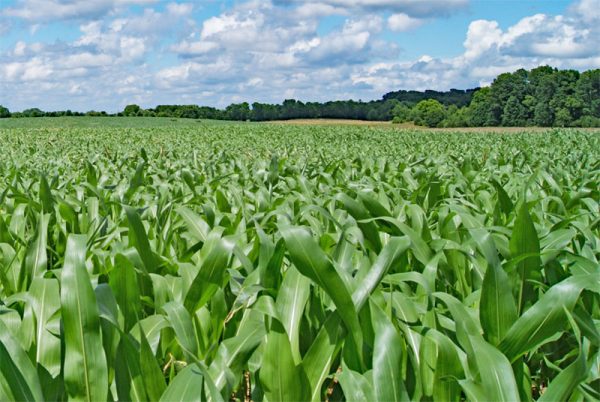
Cornfields in Western Ohio
America’s breadbasket begins in earnest in central Ohio. The farms there tend to be larger than the farms around West Liberty. I grew up on an 87 acre farm in central Ohio about twenty miles west of Buckeye Lake. We worked the ground with a 1948 Ford 8N tractor with a two-bottom plow and a 1950’s era Farmall H tractor. Our tools consisted of old horse-drawn tillage equipment which my father had welded together to use behind a tractor. Preparing and planting the 50 or so tillable acres that we farmed took about a month each spring. Today, that 50 acres is tilled and planted in one day. As we traveled west through western Ohio and into Indiana, the farms and fields became larger. Here in the northern panhandle, we consider a 300 acre farm to be a large farming operation. In western Ohio, Indiana, and Illinois and into Iowa, many of the individual fields are larger than 300 acres. We passed through mile after mile of corn and soybean fields. The breeze created waves on the cornfields that reminded us of waves on the ocean.
We passed hundreds of thousands of acres of cornfields. In fact, over 80 million acres of corn are grown in America each year. About 40 percent of that corn crop is used to produce ethanol for motor fuels and another 40 percent is used for animal feed. The remaining 20 percent is used for everything from cosmetics to breakfast cereals, to corn oil, to drinking alcohol. In addition, some of the crop is exported. We also passed thousands of acres of soybean fields. Soybeans are America’s second leading cash crop with over 74 million acres grown each year.
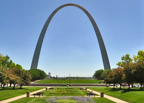
St. Louis Gateway Arch
At St. Louis, we drove past the famous Gateway Arch. As we traveled through Missouri and into Kansas, we began to see more and more fields of wheat alongside the fields of corn and soybeans. We saw gangs of two and three combines working in the fields harvesting the wheat while tractor trailer trucks waited nearby for the grain. Throughout the Midwest, large grain bins and grain elevators dotted the landscape. Long trains transporting grain and livestock often traveled alongside us on tracks that ran parallel to I-70.
We left I-70 at Kansas City, Kansas and headed north through farming country on a two-lane highway until we reached US route 36 which ran east and west in northern Kansas a few miles south of the border with Nebraska. US 36 was a wide two-lane country road through Kansas farm country with a speed limit of 65 mph. The farms and fields in that region were huge and many miles separated the farmsteads. We passed through several small towns which consisted of clusters of houses near a small store or combination store and gas station. Usually, a grain elevator and a railroad track were nearby. Most of the time, the towns had no traffic light or stop sign on US 36, so the only inconvenience was a mile or so of 45 MPH speed limit. Some of those small towns were 100 miles or more from the nearest large city. After we exited the interstate and got away from the roar of the highway traffic, we were welcomed with the sights, sounds and aromas of Midwestern farmland. The days were warm and sunny and the aroma of cornfields filled the air along with the sounds of birds and insects and the occasional voices of distant cattle. During one stop, the faint aroma of livestock-generated organic fertilizer wafted along on the gentle breeze. Even that aroma took me back to my childhood growing up on that small farm in Ohio. I was in awe of the very large farming equipment at work in the fields and really wanted to operate one of those huge four-wheel-drive air conditioned tractors!
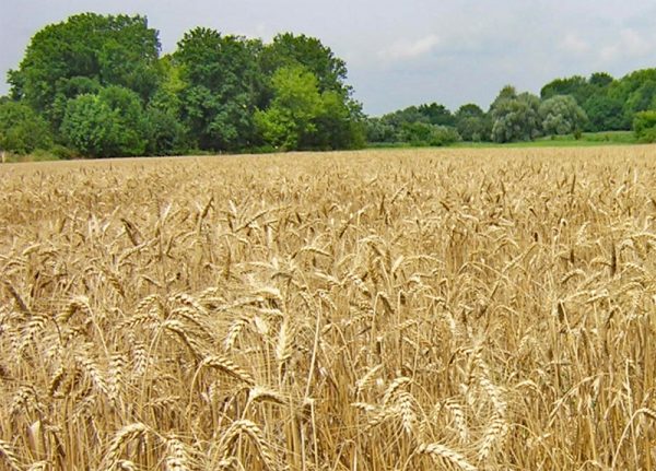
Kansas Wheat Field
In north-central Kansas, we left US 36 and headed north into Nebraska on a secondary road which intersected with I-80. The speed limit on I-80 was 75 mph. We spent the night at a small motel in farm country near I-80. As you can imagine, the place was not very busy, so I mentioned to the desk clerk that I was impressed with the 75 mph speed limit. She said that they were discussing raising it to 80 or 85 mph. In that region, I-80 is straight and there is very little traffic and very few large trucks. Many times, no cars or trucks were in sight in either direction as we traveled that highway. Less than 100 miles west of the motel, the speed limit went up to 80 mph.
I should describe a little of the driving experience. During our whole trip, the most difficult highway to drive was I-70 between Wheeling and Kansas City. Although the traffic was light, there was a lot of truck traffic on I-70 compared to most of the other roads that we traveled. Most of the other drivers on the highways were courteous and respectful and operated in a safe manner, but there were some contenders for Darwin Awards out there on the road. (If you don’t know about the Darwin Awards, Google them.) We noticed that most drivers exceeded the speed limit by 10 to 15 mph. If the speed limit was 65, they zipped past us at 75 mph or more. When the speed limit was 80, people passed us at 95 or 100. Our dash speedometer and our GPS speedometer did not exactly agree, so we usually set our cruise control to 2-3 mph over the speed limit as indicated on our dash speedometer and stayed there. We passed several officers who paid us no attention, so I assume that our GPS was correct and that we were running right at the speed limit. We saw too many drivers texting as they flew down the highway. They often swerved from side to side as they passed us or as we passed them and their speeds would often vary from ten mph over the speed limit to 10 mph under the speed limit. Betty was driving on I-80 in an 80 mph zone when we caught up to semi-truck that was going about 75 mph and weaving from the rumble strips on the berm back across the line into our lane. When the truck drifted away from our lane Betty made the pass. I noticed that the driver had his cell phone in his hand and was spending a lot of time looking at it obviously texting the whole time as we passed him. As we passed him, he sped up from under 75 mph to over 80 MPH. Studies have shown that the average amount of time spent looking at a cell phone while texting and driving is five to six seconds. At 60 mph, the vehicle travels one tenth of a mile or 528 feet in six seconds. At 80 mph, that truck traveled over 1/8 of a mile every time that driver looked at his phone for 6 seconds. By the way, the average length of a yellow traffic light in America is 4.2 seconds. If you are texting as you approach a traffic light, you may totally miss the yellow light and end up hurting or killing someone. I received a number of texts while we were on our trip. However, I always waited until we stopped or until Betty took the wheel before even looking at them. All of my friends know that I do not text and drive or text while I am in the middle of a conversation or dinner, so they know that they may not get an immediate response when they text me. No text is worth someone’s life.

Irrigation in Western Nebraska (Not my Photo – Public Domain)
As we got into western Kansas and Nebraska, we saw more and more irrigation. At first, the irrigation booms watered rectangular fields, but circular fields became more common as we traveled west in Nebraska. The huge irrigation booms pivoted around a central hub watering green circles of corn or soybeans or hay. If you lay four pennies down so that they touch each other, you will notice that an odd shaped pointed area exists between them. The farmers had planted winter wheat in those odd shaped fields between the circles and were harvesting it as we drove past. The amount of irrigated farmland in those areas boggles the mind. I kept thinking of the enormous amount of water that they were pumping out of the ground every day to water millions of acres of crops.
Our travels took us through a tiny bit of northern Colorado and through southern Wyoming into Utah. We passed many more miles of irrigated farmland, but also began to see wheat fields and hay fields. Rows of round bales of straw lined the sides of many of the wheat fields. We began to see huge square bales of hay and several times tractor-trailer trucks hauling loads of those giant square hay bales passed us on the highway. Clustered in numerous places near the highway, there were large high-roofed rectangular barns stacked full of those giant hay bales.
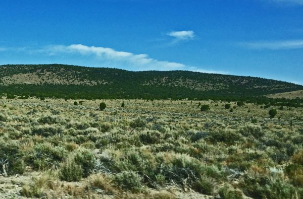
Southwestern Wyoming
By the time we reached southwestern Wyoming, the irrigated farmland had given way to brown open range land with very sparse vegetation. It looked like we were traveling through a desert and it was hot and dry. The aroma of the cornfields was gone. The sky was deep blue and the air was calm and very hot. Silence replaced the sounds of livestock and birds that we enjoyed in the farmlands of northern Kansas and Nebraska. Although very little vegetation covered the land and there were no trees to be seen, the region had a magnificence about it. For mile after mile, gently rolling hills spread out under the big western sky. A picture postcard landscape of the west stretched out in every direction.
We arrived in Salt Lake City Utah late in the evening and were fortunate to find a hotel that had some rooms available. When we checked into our room, I could not get the air conditioning unit to work. The weather channel on TV reported the current temperature to be 104 degrees. When I told the desk clerk that our air conditioning unit was broken and asked to transfer to a different room, she informed me that it was working and would come on after we were in the room for a few minutes because the hotel chain had installed a motion detector activated system that prevented the unit from running when the room was empty thereby saving energy. After an hour of dying in the heat, I went back to tell her that our room was still unbearable. She informed me that the motel was sold out, so there was not another room available and gave me a box fan. She called a maintenance guy and sent him to fix our air conditioning unit. We were dead tired as he fiddled with the unit for over an hour. Finally, he said that the core in the unit needed replaced and that he would take care of that the next day. We spent a very uncomfortable night at that hotel. We managed to prop the breeze box fan into our second floor window so that we could blow the cool 90 degree night air into the room. Later, I read online reviews of that hotel and found lots of complaints about the air conditioners not working. By the time the maintenance guy gave up, it was too late for us to look for another hotel.
Our original plan was to meet our other family members, who were traveling from Ohio and Arkansas, at Lake Tahoe. However, the unanticipated 80 mph speed limit combined with driving a few extra hours each day had put us almost a day and a half ahead of schedule. Our son, who had already driven from Arkansas to California, sent a message asking if we would be interested in meeting him for a day at Yosemite National Park. Since I had never been to Yosemite, we agreed to do so figuring that we would need a day and a half to drive the 800 miles to the eastern entrance to the Yosemite region.
Roadside Rest Area in the Bonneville Salt Flats
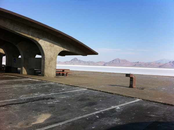
Our first stop west of Salt Lake City was at the Bonneville Salt Flats which are located in the Great Salt Lake Desert in Western Utah near the Nevada border, not far from Salt Lake City. I-80 runs right through the salt flats and the I-80 roadside rest area in the middle of the salt flats provided us with the opportunity to take a walk on the salt and experience the flats first hand. The weather was very hot and very dry, so our hike on the salt flat was somewhat short. Fortunately the rest area also included an area for cleaning the salt off of our shoes before resuming our travels.
Shortly after leaving the salt flats, we crossed into Nevada. Using the paper road atlas, I had determined that the best route was to take US route 93a to US route 6 southwest across Nevada to California. In that region, US 93a is the Lincoln Highway. Although we had filled our 21 gallon fuel tank at Salt Lake City which provided us a maximum range of around 400 miles, we topped it off at the town of Ely, Nevada before heading southwest on US route 6. The road atlas showed the next town as 117 miles away and a road sign said that there were no services for the next 120 miles. I don’t know if Nevada’s Great Basin is considered to be a desert or not, but it was very desolate. Route 6 was a two lane road which often stretched to the horizon in front of us and behind us with no other cars in sight in either direction. When we wanted to stop to change drivers or to take a picture, we did not even pull over to the side of the road. For most of the next 200 miles, we seldom saw another vehicle. The town 117 miles from Ely had no gas station. It consisted of only a couple of houses with a sign indicating that it was a town. The distance from Ely to the next gas station on route 6 was over 140 miles. Although it didn’t matter, the speed limit on Rt. 6 was 75 mph. I usually don’t speed, but my speedometer read 80 mph for much of the time that I was driving on Rt. 6.
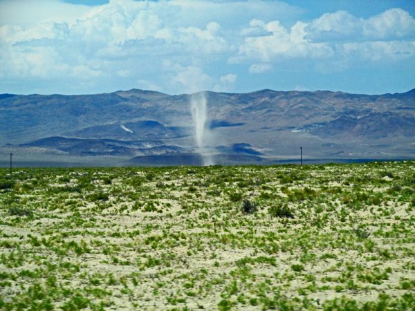
Dust Devils in the Great Basin of Utah
Although the air was calm, we often saw large dust devils which created ghost like apparitions in the distance. Although the area was extremely hot and dry with very little vegetation and no visible animals or birds, it had a strange beauty about it. It was as if God had created a three dimensional painting and dropped it onto south central Nevada. The danger inherent in driving across that region was sort of surreal. We were carrying a good supply of drinking water in our cooler and our fuel tank was full, but a breakdown in that remote locale would have been life threatening since we saw no other travelers for well over 100 miles and were far from the nearest cell phone tower.
Just inside California, we reached the town of Benton. We filled our fuel tank at the Benton Service Station and took a right turn onto California Rt. 120 which took us to the top of the world. Benton is a mile high city with an elevation of around 5400 feet. From there Rt. 120 climbs the Sierra Nevada Mountains to over 8200 feet and then goes north through a narrow flat plain between the mountain peaks before descending into the town of Lee Vining, California on Mono Lake at 6800 feet. When we saw Lee Vining along the lake, I immediately thought of the town of Lago in the movie “High Plains Drifter.” After dining at a small restaurant in the town, we visited a nearby ranger station where we learned that High Plains Drifter was filmed in that location and received information about camping in the national forest just off of the Tioga Pass road leading to the eastern entrance to Yosemite. We pitched our tent in the national forest among the tall pines near a small stream. Since the camping area had no electricity and we were some distance from the town, the sky between the trees was jet black and full of brilliant stars. The music of the water cascading over the stones in the creek quickly put us to sleep after our longest day of driving which covered just over 800 miles.
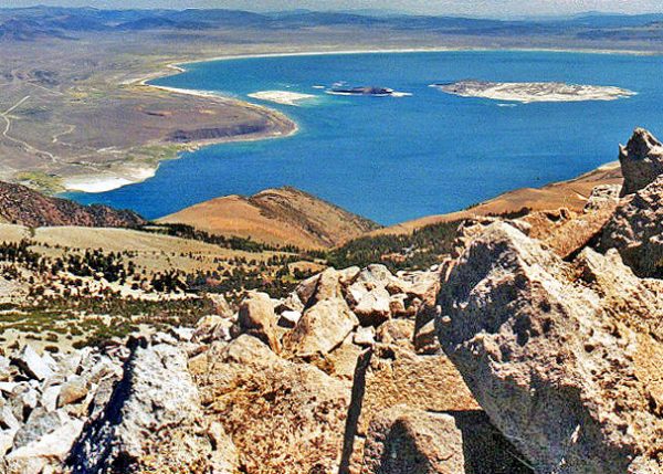
Mono Lake Near Lee Vining, California
The next morning, we went back into Lee Vining and had breakfast at the little restaurant. Thanks to a very weak cell signal, we made arrangements to meet our son on the west side of Yosemite Park. The road leading into Yosemite from the east is called Tioga Pass Road. Tioga Pass is at an elevation of just over 10,000 feet, so the road is very steep. A park entrance is located just east of the highest point of the pass. A couple of years ago, Betty and I both purchased lifetime senior citizen passes for the national parks. They cost $10.00 each and are good for admission to all of our national parks. They also give us a 50% discount on camping on all national park or national forest lands. Because of our long driving day, we had arrived at Yosemite a full half day early. Our son found a great camping area in the national forest near the western entrance to the park, so we were able to spend a full day and a half exploring Yosemite. We could have easily used a week or longer.
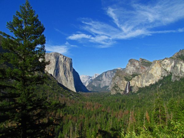
Yosemite Valley – El Capitan is on the left and Bridal Veil Falls is on the right.
John Muir and Theodore Roosevelt both called Yosemite a spiritual place. They were right. As we admired the awesome grandeur of Yosemite Valley, it was clear that God was open for business when He created that part of America. It seemed like the spirits of Abraham Lincoln, John Muir, Theodore Roosevelt and the Buffalo Soldiers who all worked to preserve the area were still there smiling from the waterfalls and rocks and trees. Since the area had been without rain for almost a month and there was no chance of rain, we left the rain cover off of our tent that first night. The top of our hexagonal tent features three screen covered windows. Soon after dark, the full moon rose and shone brightly through one of those screened windows. We were clearly camping in a very special place. The next day, we rose early to beat the crowds of tourists into Yosemite Valley. Everything in the valley seems larger than life.
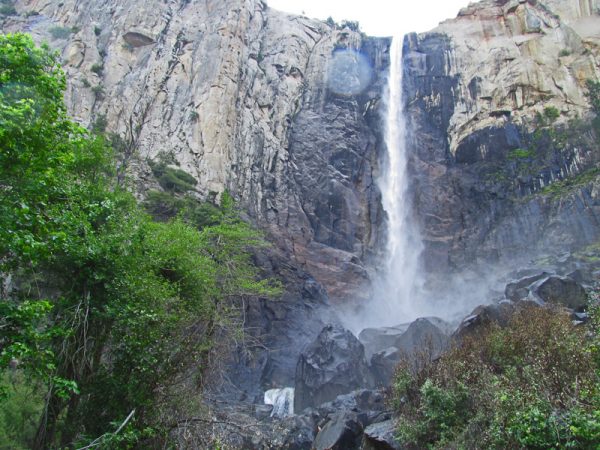
Bridal Veil Falls at Yosemite
Bridal Veil Falls gave us our first up close and personal experience with a Yosemite waterfalls. The falls gleamed brightly in the early morning sunshine which created a rainbow in the mist. When we reached the base of the falls, the cool breeze created by the falls and the mist from the falling water greeted us creating a very special experience.
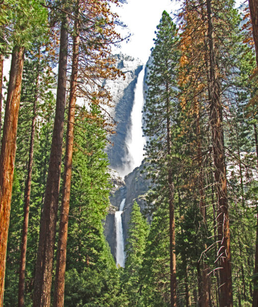
Yosemite – Upper and Lower Falls
From there, we traveled to the opposite side of the valley so that we could also visit and photograph the upper and lower Yosemite falls. Towering monuments like Half Dome and El Capitan watched over us as we experienced the valley. Every time I pointed my camera at one of the wonders of the valley, I thought of the photographer Ansel Adams whose famous photographs captured the grandeur of Yosemite Valley in black and white. However, a photograph pictures only a very small part of the valley. So, no photograph could ever capture the full magnificence of Yosemite.
After leaving Yosemite, we made our way to Lake Tahoe where we spent the night. Lake Tahoe was beautiful, but I could not help but think that the beauty of the place had been compromised somewhat when the city was built along the shores of the lake. Sometimes, we love things a little too much!
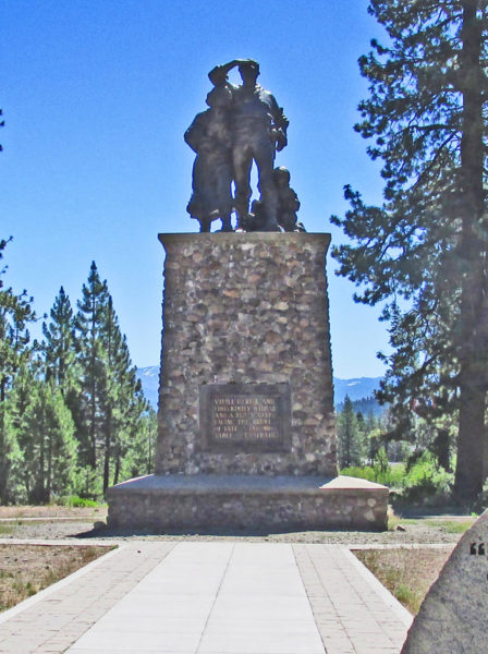
Monument at Donner Pass
Our rendezvous with our daughter and her family took place at Donner Pass just northwest of Lake Tahoe. The pass gained fame when the Donner party heading west became stranded there during the winter of 1846-47. Only half of the party survived the winter after resorting to cannibalism to stave off starvation.
After meeting the rest of the family at Donner Pass, we headed north to visit the Lava Beds National Monument in northern California. The Lava Beds National Monument encompasses portions of an extinct volcano. Located just north of Medicine Lake and Mount Hoffman with Mount Shasta only 40 miles away to the southwest, the Lava Beds National Monument features an array of caves consisting of dormant lava tubes. Since most of the caves in the region are quite remote and have no artificial lighting or other amenities, the Park Service requires cave explorers to obtain spelunking permits before entering them.
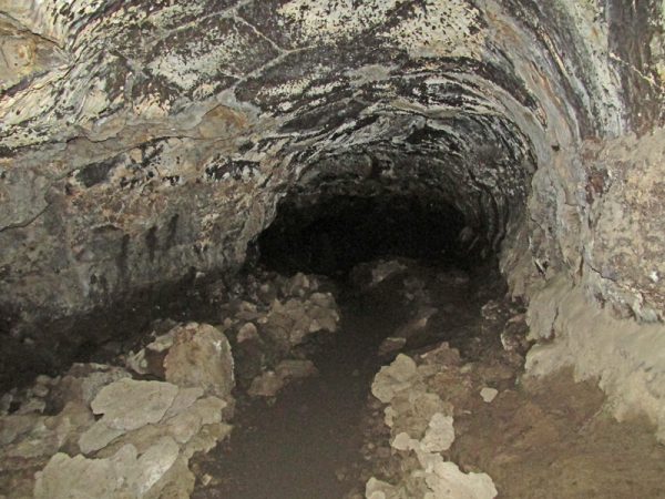
Lava Tube at the Lava Beds National Monument
Although we had plenty of flashlights and drinking water, we lacked hard hats and other caving gear, so we limited our underground adventures to the short caves near the visitor center. As the name implies, the area also features large lava beds and other volcanic features, so the geology provided a wonderful educational experience for our grandchildren and great photo opportunities at every turn.
Our family spent our first night together at a house near Crater Lake in Southern Oregon. Our group consisted of Betty and me, my sister Mary, Our son Michael, our Daughter Rachel, Rachel’s husband Jim, and our three grandchildren, Juliet, Lydia, and Heath. Rachel reserved the house where we stayed which had once been the home and headquarters for the ranger who was responsible for overseeing the area.
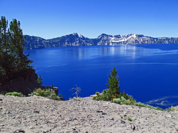
Crater Lake
With a depth of 1949 feet, Crater Lake is the deepest lake in North America and is one of the deepest in the world. As the name implies, the lake occupies the caldera of an extinct volcano. The National Park Service carefully restricts activities around the lake and boating on the lake to maintain the purity of the water which is clean enough to drink. Water in the lake comes primarily from snow melt or rain. Because the water is so pure, it filters the sunlight leaving only the blue colors to be reflected back to the observers. Therefore, the water has a very rich blue color. It looked like someone had poured dark blue ink into the water. We took a ride around the perimeter road on one of the tour busses so that the children could learn about the lake. The bus stopped often to allow the passengers to take photographs of the lake and of the spectacular views of the surrounding Sierra Nevada Mountains. However, the bus could not complete the entire loop of the perimeter road because part of the road was still blocked by snow. When we returned to the visitor center, our grandchildren enjoyed playing on the large snow drift near one of the buildings. When we left Crater Lake, we headed toward Portland where we took the kids to the zoo before heading out to Mount Hood to look for a campsite.
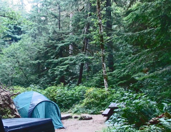
Our Mount Hood Campsite
We were fortunate to find a campsite in the national forest on the slope of Mount Hood near the towns of Welches and ZigZag. National forest campgrounds usually have very few amenities. Most of the time, they have pit toilets and no running water. Our campground on Mount Hood was one of those typical national forest camping areas. A somewhat large stream carrying melt water from the mountain ran through the campground and a ten or twelve foot high waterfall, located only a hundred or so feet from our campsite provided background music for the night.
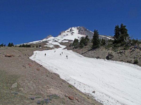
Mount Hood
While our daughter and her family went whitewater rafting the next day, Betty and I and my sister, Mary, explored Mount Hood. From the historic old lodge, the views of the mountain and of the other nearby mountains were spectacular. To the south, Mount Jefferson (Mount Jeff as the locals call it) rose above the landscape. Next to us and above us rose the snowcapped summit of Mount Hood as skiers floated down the glacier just to our right. When we left Mount Hood, we headed north to Mount St. Helens.