

Originally published Sept. 8.,2021
Can you find the coolest/weirdest/strangest detail on a map? Hint: You have to look closely…it’s all in the details.
A map’s secrets depend on when the map was drawn, who made the map, and why the map was created. It can reveal what was important to the mapmaker at the time or things that were so obvious they couldn’t be left out. It is a snapshot in time that often preserves—at least on paper—what may no longer exist or what has been lost in contemporary memory.
Take a stroll through these older maps of Wheeling and discover fantastic details about the places you thought you knew all about. Perhaps you’ll figure out who used to live at your current residence, stumble across a cemetery that has since disappeared, or find out your house was safe during the 1936 Flood!
All of the featured maps are part of the Ohio County Public Library Archives’ Map Collection. Thanks to the library, you can explore the map by clicking and dragging and using the buttons in the top left corner to zoom in and out.
1853: Map of the City of Wheeling and Suburbs of Ohio Co., Virginia
As the oldest map in the library’s collection, it was created before West Virginia was even a state! It was drawn a little less than a decade before the Civil War and includes an inventory of prominent residents and businesses. Look closely to see evidence of Wheeling expanding as a city, but also evidence of things that no longer exist on the landscape. For example, this map shows Wheeling Island in the beginning of its development because the Wheeling Suspension Bridge had just been finished a few years prior. In terms of things that you cannot find today in Wheeling, see if you can spot the “Powder Magazine” in North Wheeling.
1871: Map of the City of Wheeling, South Wheeling and La Grange, West Virginia
This map has lots of tiny little details and has significant information about who resided at each residence. It is one of the first Wheeling maps to show the arrival of the railroad through Downtown. It also has other hidden gems like the notation of a toll house on National Road and Lewis Wetzel’s Rock on the Peninsula.
Compare the 1853 and 1871 maps to discover evidence of what changed in Wheeling over almost two decades—are the street names the same? Do all the cemeteries still exist? Do the same families still own the same houses?
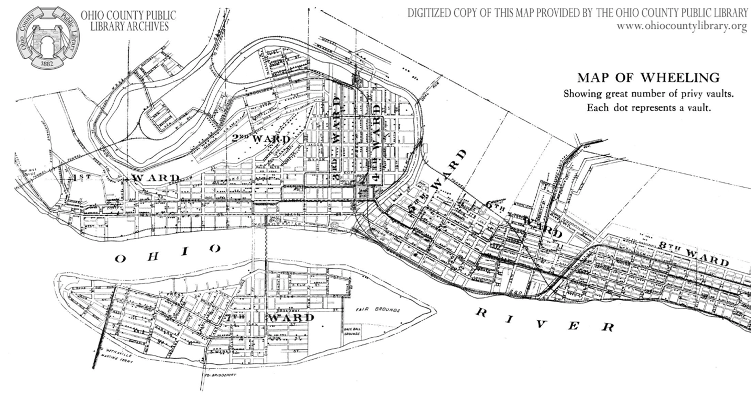
1913: Map of Wheeling Showing Great Number of Privy Vaults
…What is a “privy vault”…?
A privy vault was an outdoor toilet, usually contained within a small structure called an outhouse. It took decades for every home to have indoor plumbing, so many residents had to use privies. This map was originally published in the Report of the Health Department of City of Wheeling, West Virginia in 1913 along with other public health information and statistics.
READ MORE: The Trash and Treasure of Wheeling’s Privies
Each dot on the map represents a privy vault. If you zoom in, you can see that they were not necessarily dispersed evenly throughout the city. For example, the downtown business district of Wheeling had many fewer privies than the more residential areas. The map was created for the very specific purposes of this report, so it does not include information that might be found on other maps, such as lot ownership or all significant landmarks. But then again…most other maps don’t include privy locations…
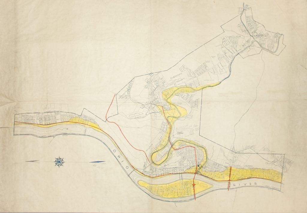
1936: Flood Map of Wheeling After the Historic 1936 Flood
Due to its proximity to the Ohio River and Wheeling Creek, Wheeling and its suburbs have been no stranger to historic floods over the years. However, the March 1936 flood was monumental with a high-water mark of 55.5 feet. More than 20,000 people were displaced from their homes and 16 people died. The yellow shading on this map indicates what parts of Wheeling were under water during the 1936 flood. More of the flooding follows the banks of the Ohio River and along Wheeling Creek. There were entire neighborhoods under water, such as South Wheeling and the Island, while other neighborhoods were protected by their steep topography, such as North Wheeling.
To Explore More…
To learn more about these specific maps of the Wheeling area or to explore other maps, visit Ohio County Public Library’s website for more digitized maps and an inventory of all the maps in the Archive’s collection. Library staff are working hard to make more maps digitally accessible and will be updating the page. To view a non-digitized map, all you need to do is make an appointment with the Archives!
In addition to OCPL’s collection, there are also digitized maps of the Wheeling area available on other platforms such as the Sanborn Fire Insurance Maps—all editions can be found here.
A great special thanks to Johnathon Porter, Dillon Richardson and the Ohio County Public Library’s staff Erin Rothenbuehler, Laura Carroll, and Seán Duffy for digitizing these maps.
• Emma Wiley, originally from Falls Church, Virginia, was a former AmeriCorps member with Wheeling Heritage. Emma has a B.A. in history from Vassar College and is passionate about connecting communities, history, and social justice.