

Editor’s Note: This is the second and final installment of the story of Earl and Betty’s epic cross-country travels. If you haven’t read the first part, you can catch up here.
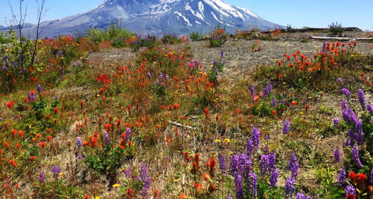
If you are a member of my generation, you will remember the 1980 eruption of Mt. St Helens. It was the most devastating volcanic eruption in United States history, as over 1000 feet of the mountaintop exploded into the atmosphere, reminding us that the volcanoes in the Sierra Nevada Range are still alive and very dangerous. A minor eruption in 2008 demonstrated that Mt. St. Helens is still an active volcano.
Mount St. Helens
Although wildflowers, small pines, and low growing shrubs bloomed on the slopes surrounding Mt. St Helens, the effects of the blast from the eruption defined the landscape. Downed trees still covered the nearby hills and the once-forested hillsides were barren except for the wildflowers and small shrubs. Even so, the area impressed us with a majestic beauty that cannot really be described in words. As with the burned and then reforested parts of Yellowstone, the region around the volcano was developing a new personality as if God was demonstrating that the cycle of life continues.

Oregon Coast
After leaving Mount St. Helens, we headed northwest to the Oregon coast where we turned north on the Pacific Coast Highway, AKA US Rt. 101. A multitude of state parks along Rt. 101 provide access to the beaches along the Pacific in that part of the country, so we stopped at several of them during our travels. Our first beach adventure took place shortly after the tide went out, so we were able to explore tide pools with the children, looking for interesting sea life. Even though the seawater was quite cold, the children still got plenty wet! We reached a small fishing town where we dined at a seafood restaurant right across the street from where workers unloaded the fishing boats. From there, we made our way north to Forks, Washington on highway 101 just outside Olympic National Park. Our daughter had arranged for the family to spend two days at a house near there while we explored the park.
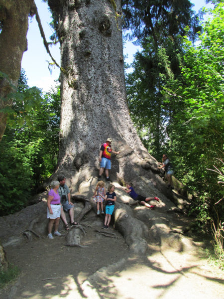
Olympic National Park – World’s Largest Sitka Spruce Tree
Left to Right – Betty, Our son, Mike, Grandkids, Juliet and Lydia, Behind them is their dad, Jim, Heath is laying on the root, Our Daughter Rachel is on the right.
Upon entering the park, we were greeted with enormous old trees. Our first hike took us past trees that were nearly 20 feet in diameter and 200 feet tall. Our son has a PhD in forestry, so he could identify them for us. Walking among trees that were alive over 1000 years ago was a spiritual experience. The tree in the picture above had a nearby sign that identified it as the world’s largest Sitka Spruce tree with a circumference of 668 inches, which translates to a diameter of around 18 feet (if my math is correct). One American Red Cedar tree in the park has a circumference of 761 inches (diameter of over 20 feet) making it the largest American Red Cedar tree in the United States.
Hoh Rain Forest at Olympic National Park
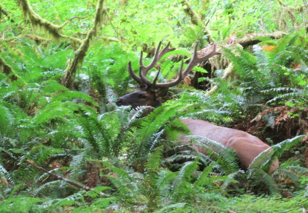
The agenda for our second day at Forks included a visit to the Hoh Rain Forest in the Olympic National Park. Fittingly, we awoke that morning to an overcast and rainy day. As we traveled the Upper Hoh Road past herds of elk along the Hoh River toward the rain forest, the rain let up. By the time we reached the Hoh Rain Forest visitor center, the area was cloudy and foggy but the rain had stopped. When we started down one of the hiking trails, the sun was streaming through the gaps in the canopy overhead, so Betty and I left our rain jackets in the truck. Everyone else in our party had on their raincoats. We had gone less than 100 yards when the sun suddenly disappeared and the rain poured down causing us to head back for the raincoats. I guess it is called a rain forest for a reason! Moss hung everywhere from trees and shrubs creating plenty of photo opportunities along the mile-long loop trail. About 200 yards from the end of the trail, two large bull elk casually grazed near the path. They seemed to enjoy posing for pictures. We had seen herds of elk near the Hoh River earlier that day, but they were farther away.
The next day, Betty and I parted company with the rest of the family to begin our trip back east. Their plans included a whale watching excursion and a visit to some of the sites in Seattle where our daughter and her family would board their train for home. Our son headed for Mount Ranier. Betty and I caught I-90 near Seattle and headed through Idaho for Butte, Montana where we spent the night before heading on to explore Yellowstone the next day. As we passed south of Seattle, the snow-capped summit of Mount Ranier dominated the scenery out our passenger side window. Near Moses Lake, Washington, east of Seattle, we passed through miles of irrigated farmland covered with those round fields. As we reached eastern Washington we began to see a lot of farm lands that were not irrigated. We often saw tall hay sheds full of those large rectangular bales near the highway.
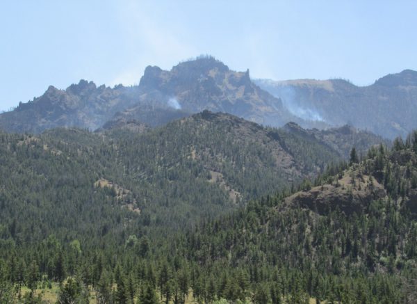
One of the Many Wildfires We Drove Past
As we traveled through Idaho, wildfires often filled the clear skies with smoke that sometimes obscured the distant landscape. We had planned to spend the night at a motel in Missoula, Montana, but the wildfires had filled the valley where the town was located with smoke and we didn’t want to spend the night breathing the polluted air, so we decided that we would drive on to Butte which was nearly 120 miles farther east. Since the speed limit was 80mph, so we only had to drive another hour and a half to reach Butte.
One benefit to driving the extra distance to Butte that evening was that we were 120 miles closer to Yellowstone. Butte was about 150 miles from Yellowstone, but the route used two-lane highways and the speed limit on those was usually only 65 or 70 mph. Even so, we arrived at the West entrance to Yellowstone by mid-morning. Our plan was to only tour the southeastern and eastern portion of the park since we have visited Yellowstone a number of times before. We last made a trip to the park after the devastating 1988 fire to see the damage, but we had not been to the park recently and I was anxious to see how well the area had recovered from those fires. In the summer of 1989, I stood on the mountainside at Yellowstone and looked out over tens of thousands of acres of blackened hillsides. However, those hillsides are now densely covered with young pine trees which looked to be around 20 feet tall. I was again reminded of the cycle of life. We exited the park via the eastern entrance road. In 2013, a fire destroyed the trees on the hills surrounding that area and those hills are still devoid of trees. After we left that area, wildfires threatened both the southern and the eastern entrances to the park.
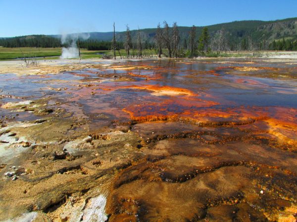
Yellowstone Hot Springs
Most people do not realize that the Yellowstone area actually consists of a huge volcanic caldera. Yellowstone is classified as an active super volcano. Hot magma near the surface contributes to the heating of the water creating the amazing water features in the park. Half of all the geothermal features on planet Earth are located in Yellowstone. We arrived at the visitor center at Old Faithful just in time to see it erupt. The eruption seemed to be about half as powerful as those that we witnessed during the 1970’s and 1980’s. I don’t know if that represents a trend or if we just happened to see a small eruption. Like Yosemite, Yellowstone provides a picture postcard no matter which way the camera is pointed. I don’t know of anyplace else where so many fascinating natural features are concentrated. Words cannot describe and pictures cannot capture the full sensory experience created by the sights, sounds, smells, and overall feel of Yellowstone. If you have never visited Yellowstone, plan on spending several days there to fully experience all of the wonders of the place!
After spending the day at Yellowstone, we headed east with plans to visit the Badlands in South Dakota. Our route took us east on US Rt. 14 past more wildfires. In one location we saw a helicopter with a large water bucket fighting a wildfire burning only a mile or so from the road as we drove by.
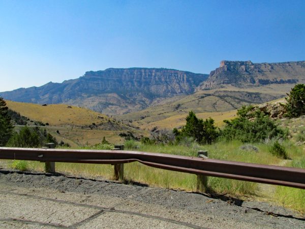
Bighorn Mountains
We followed Rt. 14 through the Bighorn Mountains until we reached I-90 in Northern Wyoming near the town of Sheridan. Rt 14 is narrow, very crooked and very steep as it winds through the Bighorns. At the highest point, our GPS indicated that we had topped 6000 feet.
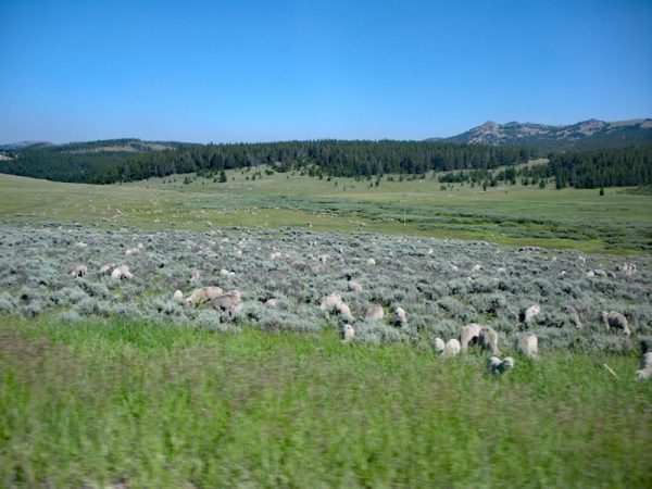
Bighorn Mountain Sheep
A couple of miles after we started descending on the northeast side of the summit, we reached a large meadow where a herd of several hundred sheep were grazing and crossing the road in front of us. We often stopped at turnouts to photograph the rugged beauty of the Bighorn Mountains and to breathe the pristine pine-scented air. However, we were relieved to leave the narrow winding mountain road behind and head southeast into South Dakota on I-90.
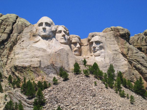
Mount Rushmore – The sky was clear and deep blue!
Near Rapid City, South Dakota, we took a little detour into the Black Hills to visit Mount Rushmore and the Crazy Horse Monument. I was especially interested to see how much of the work on the Crazy Horse monument had been completed since our last visit in the 1980s.
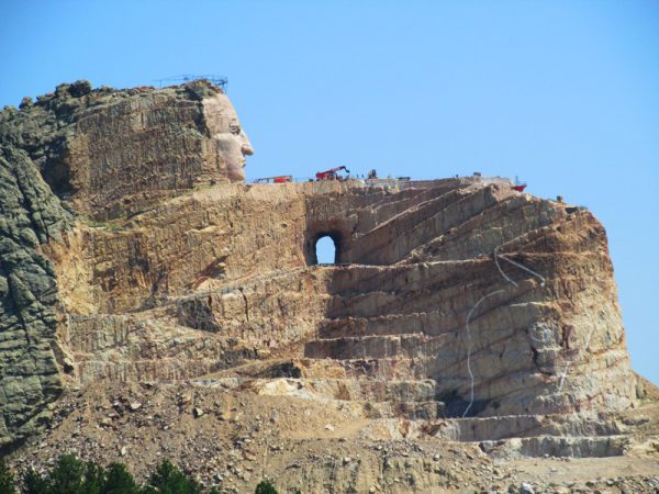
Crazy Horse Monument in the Black Hills
Almost 30 years have passed since our last visit to the Crazy Horse monument, so I expected to see a largely completed sculpture. Unfortunately, a huge amount of work remains to be done before the Crazy Horse monument is completed. I think that the commercial interests of the folks doing the work have overshadowed the plan to honor the great chief.
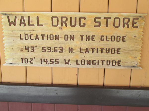
Wall Drug Store in South Dakota
One cannot travel through South Dakota on I-90 without making a stop at the famous Wall Drug Store in Wall, South Dakota near the Badlands National Monument. Wall was just like every other tiny rural town in the state until someone got the idea of expanding the drug store into a tourist trap and then using highway signs to promote it. The signs worked, so the store began handing them out and asking people to put them up back home. Those old signs read, “Only — Miles to Wall Drug.” We used to see them around central Ohio, so I thought that Wall Drug had a chain of stores! A Wall Drug sign in West Liberty would read, “Only 1308 miles to Wall Drug.” Since those first signs went up, Wall Drug has grown into one of the largest tourist traps in the country. Betty and I stopped by for some ice cream before heading on to the Badlands National Park.
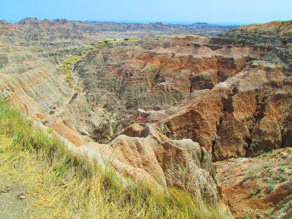
Badlands of South Dakota
To me, the Badlands look like an extreme case of soil erosion. However, the brilliant colors of eroded cliffs and hillsides create a work of art on an enormous scale. The loop road includes lots of turnouts which provide plenty of photo opportunities. One section of the park provides a home to a large population of prairie dogs, so it is known as Prairie Dog Town. As we drove the loop road, we also photographed bighorn sheep. Signs warned of bison on the road, but we did not see any. The area is hot and dry, so take plenty of water if you decide to visit. After leaving the prairie dogs and the Badlands, we continued travelling east on I-90 until we reached Sioux Falls where we turned south onto I-29 so that we could head down to Omaha to join up with I-80. As we drove through the eastern half of South Dakota, we noticed that much of the eastern part of the state was filled with non-irrigated farms similar to those in Indiana or Western Ohio. At Omaha, we headed east through Iowa.
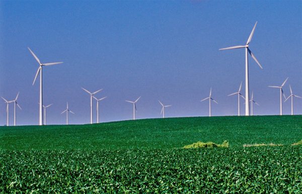
Iowa Wind Farm
Over Iowa’s hills the windmills blow
Between the cornfields, row on row
That cover the landscape, and in the sky
The birds still bravely singing fly,
Their music carried on the breeze below.
Throughout our trip, we frequently passed large wind farms. We saw several rows of hills filled with wind generators as we drove through Iowa. At one point, three extra-long trucks carrying the blades for a wind generator passed us as they were heading west giving us a little appreciation for the length of those blades. Not long after that, we spotted a white spire in the distance shining in the morning sun. It rose high into the air next to a small building. When we reached that area, we discovered that the spire was actually a wind generator blade standing vertically next to a small tavern along the access road that ran alongside I-80. I did a little research and learned that most wind generator blades in the US measure around 116 feet in length although some of the newer wind farms have started installing larger units with blades measuring 148 feet in length. Since we took most of our photographs from a distance, the huge scale of the wind generators was not apparent. I have mixed feelings about the wind generators. They provide cleaner electricity, but they are a threat to birds and they create an eyesore on the landscape.
The Iowa landscape reminded me of east central Ohio with its gently rolling countryside filled with corn and soybean fields. Much of the farmland in South Dakota and Nebraska had very few trees. When we reached eastern Iowa, the countryside had lots of trees, so we began to feel like we were getting close to home. We spent our last night on the road on the east side of Indianapolis, Indiana and drove home the next day.
Five miles from West Liberty!
How would I describe America? As I said at the beginning, America is big. Most of the people who we met during our trip were very helpful and friendly. From the West Virginia hills to the fields of Iowa to the wonders of Yellowstone and Yosemite to the rugged Pacific coast in Washington and Oregon, America truly is beautiful. As we drove down the hill on Rt. 88 leading into West Liberty and passed through the tunnel formed by the trees along both sides of the road, I realized that no place else in America is more spectacular that this place that we call home.