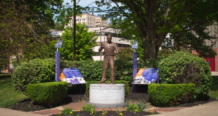
Have you seen the signs around Wheeling that have a bit more in-depth information about the neighborhoods, buildings, people, and history of Wheeling? If you have, you’ve seen one of Wheeling Heritage’s Interpretive Signs! These historical markers have the main goal of helping both Wheeling residents and out-of-town visitors to better understand parts of our city’s history. Wheeling is a National Heritage Area, which is a place designated as a part of our country’s landscape that has been recognizes by Congress as a unique contribution to the American experience. The signs are there to explain pieces of Wheeling’s place in history and what makes the Friendly City so unique.
A current total of 21 signs are currently dotted around Wheeling:
- Augustus Pollack – Located at Heritage Port – Tells the story of the monument dedicated to the German-born “friend of organized labor”
- B & O Railroad – Located in front of the B&O Railroad Terminal Building, now West Virginia Northern Community College – Describes the B & O terminal’s story from the first train arriving in 1852 to the last train departing in 1961.
- Centre Market – Located between the two halves of the market house in Centre Market – Explains some history and culture behind both the structure and the greater Centre Market District
- Chapline Street – Located in downtown near the base of the Chapline Street Hill – The newest interpretive sign, it tells the story of the now-demolished African American part of downtown from the years of Jim Crow Laws in the US
- East Wheeling – Located just off of 16th Street in East Wheeling – Describes many of the interesting historical reasons why East Wheeling is a historic district within Wheeling, particularly due to commerce and industry
- Elephants in Wheeling – Located on Main Street and 11th – Details the story of the circus coming to Wheeling and the metal sculptures that stand as tribute in a small park on Main Street
- Elm Grove – Located just off of the Greater Wheeling Trail in Elm Grove – Describes many of the interesting historical reasons why Elm Grove is a historic district within Wheeling
- Fort Henry – Located on Heritage Trail along the Ohio River just south of the Suspension Bridge – Tells the (bloody) story of this illustrious fort that predated the formation of the United States, including that of McColloch, Betty Zane, and the Mingo
- Hempfield Viaduct – Located on the Greater Wheeling Trail near Tunnel Green – Tells the story of the viaduct, built in 1853 as a railroad bridge to connect Wheeling to Washington, PA
- Mail Pouch Tobacco – Located just off of Heritage Trail near 36th Street in South Wheeling – Explains the history of the nationally recognized tobacco company and its founders
- Marsh Wheeling Stogies – Located on Heritage Trail along the Ohio River – Describes Wheeling’s “Workingman’s Stogie” factory, which operated in downtown for 161 years before moving to Indiana in 2001.
- North Wheeling – Located on Heritage Trail at 8th Street in North Wheeling – Explains many of the interesting historical reasons why North Wheeling is a historic district within Wheeling
- Pennsylvania Depot – Located just off of Heritage Trail at the northern point of Heritage Port – Tells the story of the now-demolished Pennsylvania Railroad Depot, a competitor of the B & O Railroad
- South Wheeling – Located on Chapline Street and 36th Street – Explains many of the interesting historical reasons why South Wheeling is a historic district within Wheeling
- Walter Reuther – Located at Heritage Port – Two signs that tell the history of American labor leader, Civil Rights activist, and Wheeling local Walter Reuther
- Warehouse District – Located on Heritage Trail south of the creek – Describes the heyday of production, commerce, and industry in downtown Wheeling’s Warehouse District
- Warwood – Located at Garden Park – Explains many of the interesting historical reasons why Warwood is a historic district within Wheeling
- Wheeling Creek – Located on Heritage Trail right on the creek – Explains the historical prominence and usefulness of the Big Wheeling Creek the flows through town
- Wheeling Suspension Bridge – Located on Heritage Trail just south of the Suspension Bridge – Tells the story of Wheeling’s famous Suspension Bridge
- Wheeling Wharf – Located right at the heart of Heritage Port – Describes Heritage Port and its key role in transporation, innovation, and industry in Wheeling
- Woodsdale/Edgewood – Located on the corner of South Park St. and Carmel Road – Explains many of the interesting historical reasons why Woodsdale and Edgewood are a historic district within Wheeling
See the entire list of signs and a virtual map of their locations at wheelingheritage.org and stay tuned for some major updates to this signage system, coming soon!